
MH370: How the Greatest Aviation Mystery is Also the Biggest Cover-Up
MH370: How the Greatest Aviation Mystery is Also the Biggest Cover-Up
How sophisticated state actors used decoys, secret tech, and mass deception to stage the perfect cover-up


Since the Malaysian government announced loss of contact with the plane on March 8, Malaysia Airlines, the Malaysian government and the Malaysian military made every effort to postpone and conceal the truth in the past 18 days, attempting to deceive passengers' families, as well as the world. – Passenger Families’ Statement
Malaysia Airlines flight MH370 looked like a typical flight. The passengers were screened and seated, the pilot and crew reported for duty, and the baggage and cargo were loaded. The plane had undergone its required maintenance and inspections, leading official investigators to conclude the plane was airworthy. This was not a plane that should have an accident. Based on the evidence, it didn’t.
What happened to MH370 was planned, expertly executed, and masterfully covered up.
To find the truth of MH370, we must challenge all assumptions, including our current understanding of science. We must let the data lead in the formation of theories. We must be willing to look at all of the evidence, even if it disagrees with our theory or is used in support of theories we believe to be wrong. Where there is no evidence, we can apply logic and reasoned speculation to fill in the gaps. Through questioning, analysis, and a relentless pursuit of truth, we will uncover the real story of MH370. In so doing, we may learn the fate of those who were taken.
This article explores what happened that bizarre and fateful night of March 7, 2014 on the red-eye flight to Beijing. It presents a comprehensive new hypothesis that fits together the key evidence, including radar data, witness accounts, debris, and who and what was on board, as well as leaked classified videos showing the plane’s disappearance into a possible wormhole. I am not claiming it is 100% correct or complete. It represents the conclusions I have drawn based on the facts available to me. It is my best attempt to make sense of the mystery, being as intellectually honest and objective as I can.
As we piece together the evidence, we see a complex plan with several contingencies, involving multiple planes, deliberate attempts to evade detection, and advanced technology kept secret from the world. We see a cover-up of epic proportions with staggering real-world implications. This hypothesis, if correct, exposes the depth of state secrets, lies, and deceit, but also the hope of a brighter future through technology that changes everything.
MH370 may be the tipping point for total revelation and the advent of free energy.
Loss of communications provides the cover for a covert operation
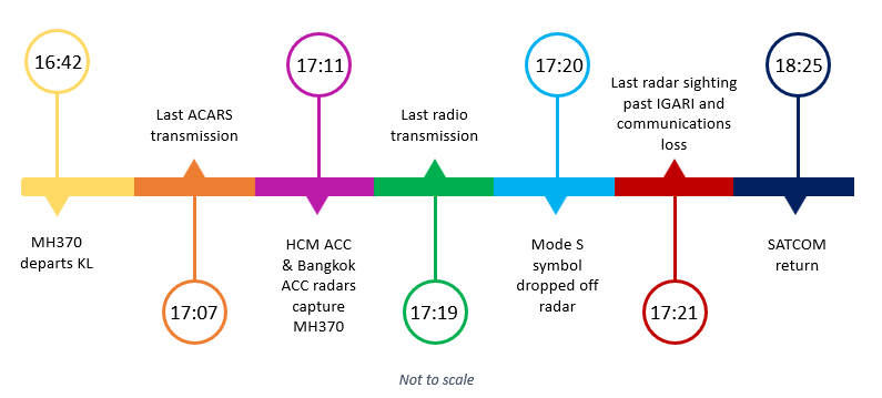
On March 7, 2014, Malaysia Airlines flight MH370 took off from Kuala Lumpur airport at 16:42 UTC (12:42 AM Malaysia time) en route to Beijing, China. The plane ascended to a cruising altitude of 35,000 ft, fully visible to air traffic control. At 17:19 UTC, the pilot acknowledged the request from Kuala Lumpur Area Control Centre (KL ACC) to contact Ho Chi Minh Area Control Centre (HCM ACC) with what would be the plane’s last radio transmission: “Good night Malaysian Three Seven Zero.”
Just two minutes later, at the expected handover from KL ACC to HCM ACC, the plane’s transponders were disabled and MH370 disappeared from civilian radar. At 17:20 UTC, the Mode S symbol of MH370 dropped from radar display. At 17:21 UTC, the last secondary radar position symbol of MH370 was recorded near the IGARI waypoint. The on-duty Air Traffic Control Officer (ATCO) at Kuala Lumpur later stated that he did not notice when the plane dropped from radar because he was watching four other flights. Additionally, the controller at HCM ACC did not contact the Kuala Lumpur center until 17:39 UTC, well beyond the five minutes required by protocol. The HCM ACC controller “could not explain why he did not initiate any call to MH370 within the standard 5 minutes” (SIR, p. 15).
Thus, there was a period in between jurisdictional transfer of control when the ATCOs were unaware the plane was missing, followed by an extended period of confusion when no one could locate or contact the plane.
The SATCOM system goes dark
The MH370 aircraft, registered as 9M-MRO, was equipped with multiple means of communication, providing redundancy in the event of single point failure. In addition to radio and radar transponders, it had a sophisticated satellite communication system (SATCOM) with five voice channels and one data channel. SATCOM communications are relayed through a nearly global constellation of satellites operated by Inmarsat, linking the Airborne Earth Station (AES) in the aircraft to a network of Ground Earth Stations (GES). In addition to in-flight entertainment, the satellite link provides audio and text communication and Aircraft Communication Addressing and Reporting System (ACARS) data. ACARS is used to send operational reports, such as engine performance, fuel monitoring, and fault messages, as well as position reports providing current coordinates.

The ACARS data link was fully established on SATCOM prior to take-off. Flight MH370 sent two engine reports, with the first at 16:41 UTC and the last at 16:52 UTC, both showing normal operation. The only position report was sent at 17:07 UTC, with subsequent reports to be sent every 30 minutes (SIR, p. 113). The next scheduled report at 17:37 UTC was not received. Additionally, the Malaysia Airlines (MAS) command center attempted to send a message to the cockpit via ACARS at 18:03 UTC, but received an automated failure notice. Curiously, the official Safety Investigation Report stated that, “even if the on-board ACARs equipment was failed, disabled or powered down at this time, it would not prevent the SATCOM from acknowledging the ACARS-related P-Channel transmissions from the GES” (SIR, p.125).
It seems the satellite data unit (SDU) that processes signals between the plane and satellite logged off and powered down, which is highly unusual.
The SATCOM link and ACARS data exchange was lost sometime after 17:07 UTC. Given that the pilot’s 17:19 UTC radio communication with KL ACC did not note any system failures, it is reasonable to assume the SATCOM link was severed after 17:19 UTC, immediately before disappearance. Additionally, had there been a mechanical or electrical event on board at the time of MH370’s disappearance, ACARS would have transmitted a fault message in real time (SIR, p. 50). That no such message was received suggests: (1) the ACARS system was inoperable at the time of disappearance, (2) the drop from radar was not due to a mechanical, electrical, or operational fault, or (3) both.

SATCOM returns without its critical data link
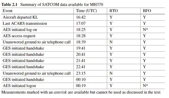
Despite apparent SATCOM failure, the system powered on at 18:23 UTC and initiated a log-on request at 18:25 UTC, just 75 seconds and 3 minutes, respectively, after the last officially-reported military radar contact at 18:22 UTC. This is uncommon. As noted in the SIR, “This log-on request suggests that whatever caused the SATCOM link loss to occur between 1707:48 and 1803:41 had been reversed,” resulting in the restoration of the SATCOM link, with three caveats (SIR, p. 125).
First, SATCOM resumed normal operation except for the ACARS data link, which would have provided a clear picture of what was happening and where the plane was. Second, the log-on request was missing a valid Flight ID (MAS370), which would confirm that the communications relayed through SATCOM were coming from MH370. Third, two ground-to-air telephone calls using SATCOM at 18:39 and 23:13 UTC connected but went unanswered.
With SATCOM online, the “handshakes” between the GES and AES resumed until the SATCOM stopped responding at all at 01:15 UTC on March 8. These handshakes—the only information gleaned from the SATCOM system after its initial failure—formed the basis of the arcs along which MH370 was said to have flown, directing the search for the missing plane to the South Indian Ocean.
The perfect storm
Every crime needs an opportunity. For MH370, there was a 66-minute blackout (17:19 to 18:25 UTC) when no communication took place to or from the plane, save for a muffled radio call on the emergency frequency at 17:30 UTC. Critical events affecting MH370, specifically the disappearance from radar and apparent manual western turn, occurred during this blackout period. When the SATCOM link was suddenly restored at 18:25 UTC, it was without the data system that would reveal the plane’s condition and location. The only successful communication was a series of handshakes that pointed rescue efforts to the South Indian Ocean. This satellite data wasn’t publicly acknowledged until Day 6 of the search. The search in the South Indian Ocean didn’t begin in earnest until Day 10, lessening the chances of the plane being found. Without the plane and its black box, the fate of MH370 would be unknown.
The official report stated there was no evidence that the SATCOM was manually turned off via cockpit controls, as pilots are not trained to do that and the GES would have logged that action (and it didn’t). The report’s most likely explanation was a lengthy power interruption. However, no fault messages were received and the report concluded other major elements of the plane’s electrical system were functional. If the SATCOM failure was due to a power failure, it was apparently the only system affected. There is no information on what would have caused a power failure, later restored power, or caused the system to power-up without ACARS.
Similarly, if the SATCOM failure was due to a fire, the fire seems not to have catastrophically impacted the system (given that it came back online), nor impacted other nearby systems or the ability to continue flight. Additionally, after extensive analysis and testing, the Safety Investigation Report found no evidence of a fire, nor could they replicate conditions to start a fire (SIR, p.368). The cargo and possibility of a fire is discussed in greater detail later.
More likely was a breach of the electronics and equipment bay. Aviation journalist Jeff Wise has revealed vulnerabilities that would allow access to the bay from a hatch in first class.
Someone could have snuck or forced his way into the bay and flipped breakers to disable (and then re-enable) the SATCOM system.
It is also worth noting that the SDU, which is required for sending and receiving messages, is in the ceiling above the passenger cabin, toward the back of the airplane, close to the plane’s antenna. Someone with the appropriate expertise could have accessed the SDU, turned it off, and/or changed parameters. Initially, there was some speculation that a Malaysian aviation engineer sitting below or near the SDU could have played a role in a hijacking attempt. However, that remains speculation.
The radar data points to more than one plane
In the days following the disappearance, news spread of a possible “turn back” over the Malaysian peninsula. However, the information provided by the government was unsupported by hard proof and often conflicting. As noted by The Guardian, “Malaysian officials have given ambiguous, inaccurate and at times directly contradictory information since the aircraft's disappearance.” This is particularly true when it comes to the radar data.
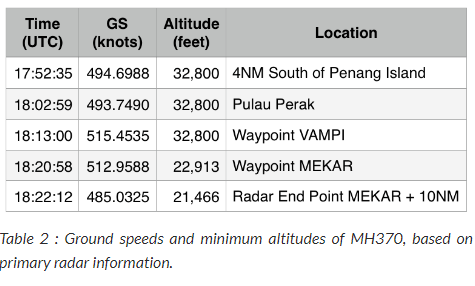
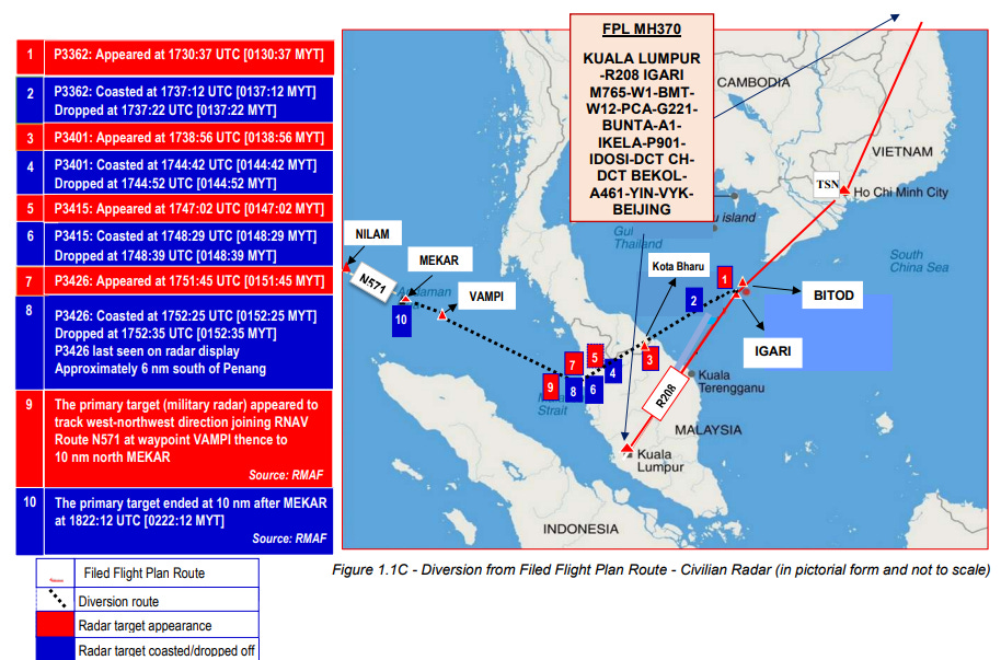
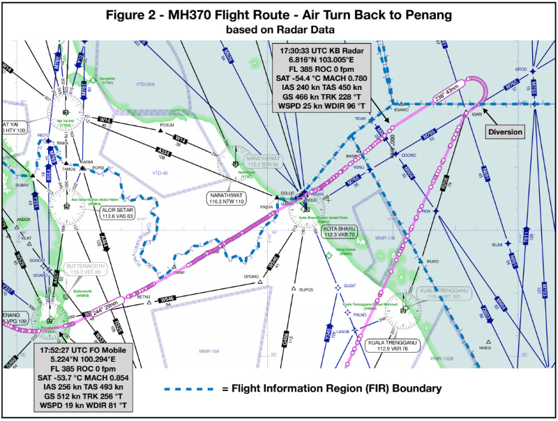
As mentioned above, MH370 disappeared from civilian radar at 17:21 UTC as it passed the IGARI waypoint on the route to Beijing, initiating a period of uncertainty and confusion about the plane’s whereabouts. At this time, the official report notes the “return” of MH370 to Malaysian military radar, though there is discrepancy over how much time, if any, elapsed between the civilian radar drop at 17:21 and military radar return. The Royal Malaysian Air Force (RMAF) radar showed what was assumed to be MH370 making a 180-degree left turn, crossing back over the Malaysian peninsula, at an altitude of 31,150 ft. According to the official account, RMAF tracked the plane until radar dropped again at 18:22 UTC approximately 10 nautical miles (nm) north of the MEKAR waypoint in the Straits of Malacca. It was traveling north-west along flight route N571 toward NIKAM waypoint.
An independent report, The Final Resting Place of MH370 by Bobby Ulich, Richard Godfrey, Victor Iannello, and Andrew Banks, suggests RMAF provided investigators with continuous data from departure at 16:42:27 UTC to 18:01:49 UTC at 10-second intervals, with an additional final radar capture at 18:22:12 UTC. The report also claims the projected flight path from departure to the 18:22 UTC plot past MEKAR is all well within range of the Malaysia military’s Western Hill radar, meaning it should have had continuous 10-second interval primary radar data for the entire time period and a bit beyond. Yet, according to the RMAF, it didn’t.
The changing story of RMAF radar data
The RMAF relied on primary radar data to conclude MH370 turned back toward the Straits of Malacca. Unlike secondary radar that communicates with a transponder to provide data, primary radar uses a ground-based antenna to transmit a radar pulse, then waits for the return signal reflected back. It is confirmation of an object and its approximate placement but further information is based on assumptions and calculation, not direct data. Thus, the identity of the plane on radar was implied based on “its track behaviour, characteristics and constant/continuous track pattern/trend” (SIR, p. 6).
However, the radar data shows behavior out of spec for a Boeing 777 (SIR, p. 3-4). Despite the unidentified craft exceeding maximum speeds and altitudes for a passenger plane, the RMAF allegedly believed it to be a civilian aircraft and therefore friendly. They ignored it, later claiming the radar speeds and altitudes presented in the official report were erroneous. They also claimed they were not monitoring the plane in real time and had to depend on a playback, which contradicts claims that they deemed it friendly and justifications for taking no action, like sending fighter jets to investigate.
As noted by researcher Ken St. Aubin, this magnitude of error is unlikely for sophisticated military equipment intended to protect a country’s airspace.
If the radar system was so addled with error that they would dismiss a plane spiking to 58,000 ft and then plunging to 4,800 ft in a minute, what is the point in having it? Are we to believe Malaysia’s airspace is not being monitored in real time?
Absent compelling explanation and evidence to the contrary, this speed and altitude data should be taken as accurate within a reasonable margin of error due to range limitations and other factors. If we accept it as mostly accurate, this data cannot come from MH370. It can only come from military aircraft, like a fighter jet.

The above data was only published in the official report in 2018. It loosely (but not perfectly) aligns with separate radar imaging shown to families at a March 21, 2014 presentation at the Lido Hotel, which was analyzed by Bill Holland of the Independent Group and recirculated by a researcher on an aviation site. The annotated graphic, shown below, has the unidentified plane at Pulau Perak at 18:03 UTC, immediately following a brief period of missing altitude data in the official report’s RMAF data shown above (the line between the 18:01 and 18:03 data points is inferred not observed).

Given the low altitude reported in the official RMAF data, it is possible that a plane landed on or near Pulau Perak sometime between 18:01 and 18:03, though the speed data calls that into question, if accurate. However, the Lido Hotel image shows constant movement away from Pulau Perak until 18:07 UTC, which is problematic for the landing theory, if the data is showing the same plane. There are a few possible explanations. First, the time stamps (or the researcher’s calibration of them) could be wrong, such that the data gaps start at the same time. If we take the data as-is, it is possible the jet cruised at or below 4,800 ft past Palau Perak until it dropped off military radar for six minutes starting at 18:07 UTC. Then it climbed back up to cruising altitude as it made its way past VAMPI at 18:13 UTC and MEKAR at 18:22 UTC, thus matching the end point of the two RMAF data sets.
Also confounding is Bill Holland’s analysis of the timestamps, which found ground speeds ranging from 485 to 515 knots, which are exceeded by the RMAF values in the official report. The team assigned minimum altitudes, which also conflict with the official RMAF data that reports an altitude of 4,800 ft at 18:02 UTC.
Further complicating matters was a March 14th Reuters report based on anonymous sources close to the investigation, offering a sketch of the primary radar. This was one week before the presentation at the Lido Hotel. From the sources, Reuters reported:
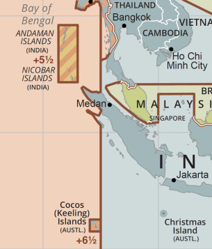
The military track suggests it then turned sharply westwards, heading towards a waypoint called "Vampi", northeast of Indonesia's Aceh province and a navigational point used for planes following route N571 to the Middle East. From there, the plot indicates the plane flew towards a waypoint called "Gival", south of the Thai island of Phuket, and was last plotted heading northwest towards another waypoint called "Igrex", on route P628 that would take it over the Andaman Islands and which carriers use to fly towards Europe. The time was then 2:15 a.m. That is the same time given by the air force chief on Wednesday, who gave no information on that plane's possible direction.
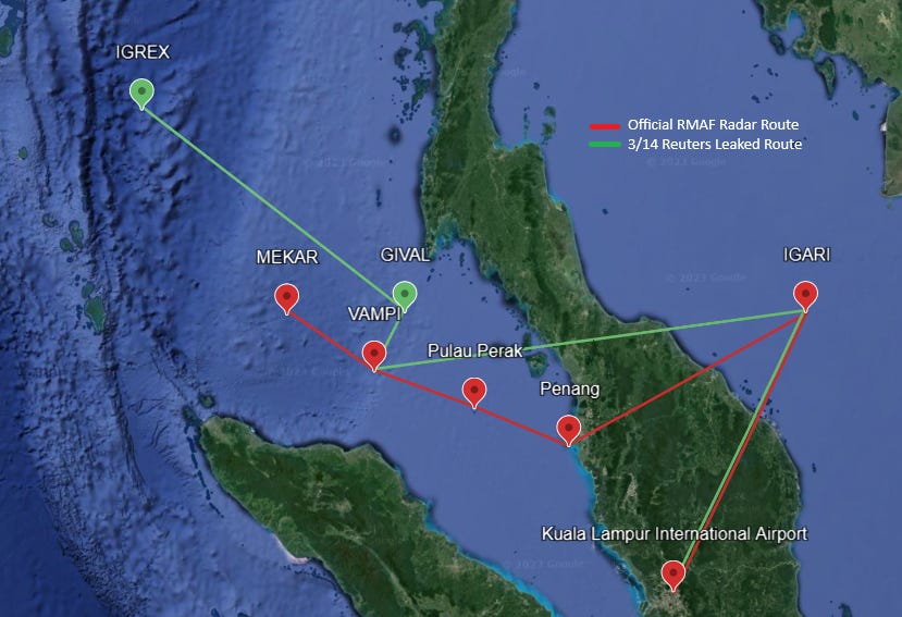
This 2:15 a.m. timing comes from a Wednesday, March 12th statement by the air force chief claiming “the missing plane was plotted on military radar at 2:15 a.m., 200 miles northwest of Penang Island.” Despite Reuter’s claims of matching statements, the IGREX waypoint is approximately 440 nautical miles from Penang Island, not 200. A passenger plane flying at 500 knots could not reach IGREX at 2:15 a.m. via that route. It would take approximately 80 minutes or until 18:40 UTC, assuming 500 knots.
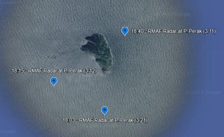
Curiously, the same air force chief was quoted the day before, Tuesday, March 11, in a local paper as saying the last radar contact was at 18:40 UTC, which would align with the IGARI-VAMPI-IGREX route timing. However, he placed the plane near Pulau Perak at 18:40 UTC, which conflicts with the Reuters (and official) flight path and his statement the next day. A couple of days later, the chief denied the 18:40 radar data, pointing back to a March 9th press conference when he merely referenced the possibility of a turn back.

It is possible that the chief’s March 12th statement of a plot at 2:15 a.m. at Pulau Perak was correct. Pulau Perak is approximately 200 miles (or 174 nautical miles) northwest of Penang. Depending on the route, the flight time is approximately 40 to 50 minutes assuming an average speed of 500 knots. This would place the plane at Pulau Perak around 2:03 to 2:13 a.m. Malaysian time (18:03 to 18:13 UTC), satisfying the 2:15 a.m. data point. However, the timing doesn’t match what was shown one week later at the Lido Hotel.
As shown in the image below (location dispersed for ease of viewing), the plots at Pulau Perak were revised earlier from 18:40 to 18:15 to 18:03. Given flight assumptions, the 18:40 value can likely be eliminated. Both 18:03 and 18:15 are plausible. Either one is wrong or, as discussed below, the radar plotted two different planes in the same location within 15 minutes of each other.
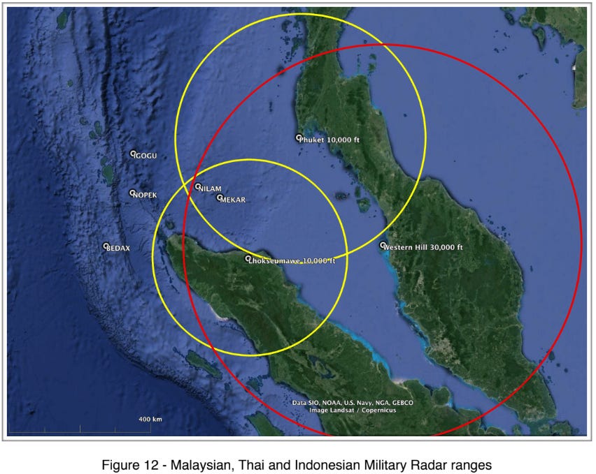
Certainly, the RMAF’s reporting of the radar data is suspicious. It is not clear why the military radar playback reviewed the morning the plane went missing would result in three conflicting claims. Also suspect is the observation by journalist Florence de Changy that MH370 flew in heavily monitored airspace, due to several military powers active in the region. The plane potentially touched or approached six countries’ airspace—Malaysia, Indonesia, Thailand, Vietnam, Singapore, and Australia—yet no country produced raw radar images or footage or gave a verifiable account of the plane’s movements. Neither did any of the satellites constantly and completely surveilling the globe.
That a rogue 777 flying seemed to garner no attention, action, or footage suggests it wasn’t rogue.
Several questions remain unanswered. Which RMAF radar data sets, if any, are correct? What caused the gaps in radar data collection? Are these the flight paths of two (or more) planes? What role, if any, did Pulau Perak play in the operation?
The unidentified plane on civilian radar
From 17:30 to 18:01 UTC, civilian primary radar installations at Kota Bharu and Butterworth AFB recorded sporadic blips from an unidentified aircraft, which was assigned temporary transponder codes each time it appeared. There was no altitude information. According to an independent expert report, the radar data is in the form of (slant) range and azimuth from the rotating radar head, which requires assumptions to infer the corresponding longitude and latitude.
Their analysis estimated that the aircraft was flying at about maximum operating Mach value (Mmo) of 0.870 (true air speed of 507 knots) and at about FL385 (standard altitude of 38,358 ft) as it passed through Kota Bharu radar coverage around 17:30-45 UTC. It was operating consistent with long range cruise.
According to the anonymous account of a controller on duty that night, the craft’s appearance and disappearance off primary radar was unlike anything he had seen in his many years of experience. Typically, a crash would be the reason for a primary radar signal to vanish, yet these signals kept returning until the object left the coverage area.
The Royal Thai Air Force noted that at 17:28 UTC, Thai military radar "was able to detect a signal, which was not a normal signal,” of a plane flying back toward Kuala Lumpur. The plane then turned right, toward Butterworth Air Force Base. Like the Malaysian civilian radar, the radar signal was infrequent and did not include any data such as the flight ID. Reportedly, the Indonesian military radar at Sabang, which could have provided additional corroborating flight path data, was not operational that night.
Are the gaps in radar signals evidence of two US AWACS (Airborne Warning and Control System) aircrafts in the area jamming signals, as reported by journalist Florence De Changy?
There seems to be a point of convergence at 17:52 UTC when RMAF shows a blip 10 nm south of Penang, civilian radar drops about 2 to 6 nm south of Penang, and the co-pilot’s cell phone pings a Penang cell tower (SIR, p. 20).
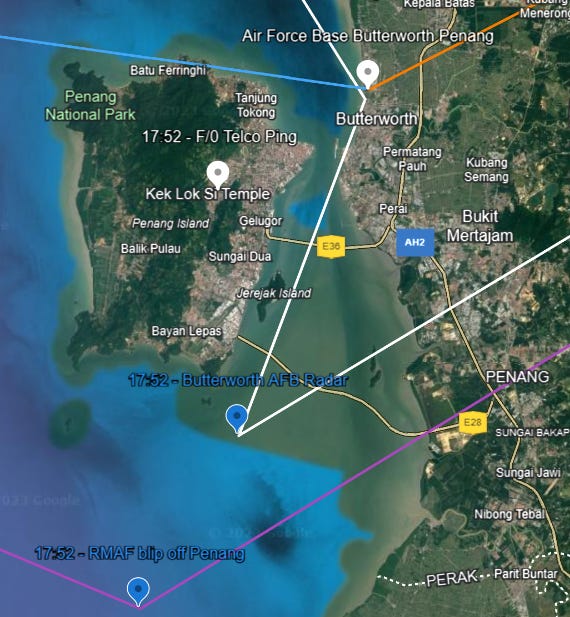
This could corroborate the official flight path routing through Penang, Pulau Perak, VAMPI, and MEKAR, hitting Pulau Perak at 18:03 UTC, as it would take about 10 minutes for a plane flying 500 knots to travel from Penang to Pulau Perak. However, there are two discrepancies. First, the RMAF shows the plane 10 nm south of Penang just 4 milliseconds before it is reported 2-6 nm south on civilian radar. Second, the RMAF data shows an altitude of 44,700 ft, which would be far too high to register a cell phone ping.
Again we ask: were there two (or more) planes?
Also interesting is that the assumed flight path across Malaysia mostly hugs the border of Malaysia and Thailand. Similar to the confusion created earlier in the flight when MH370 lost communication at the border between Malaysian and Vietnamese airspace, flying along this border could create ambiguity of responsibility and avoid alarms by skirting foreign air space.
Is this another attempt to avoid detection?
The Inmarsat data
The presumed location of MH370 in the South Indian Ocean is based on complex calculations using the Burst Timing Offset (BTO) and Burst Frequency Offset (BFO) measurement data from Inmarsat. The BTO is “essentially the delay between when the transmission was expected (given a nominal position of the aircraft) and when it actually arrives, and is a measure of twice the distance of the aircraft from the satellite.” The BFO is “the recorded value of the difference between the received signal frequency and the nominal frequency at the GES. It is determined by several factors including the aircraft’s location and ground velocity.”
These values, present in the handshakes, had never been used to calculate location. After extensive analysis and sophisticated math, the Inmarsat values were used to conclude: (1) the plane was operational for at least seven hours after loss of contact (5 ½ hours after last radar contact), (2) the navigational system was operational, (3) the plane was moving, and (4) the southern arc was the most probable flight path. Specifically, an analysis by Inmarsat concluded, “MH370 changed course shortly after it passed the Northern tip of Sumatra and travelled in a southerly direction until it ran out of fuel in the southern Indian Ocean west of Australia.”

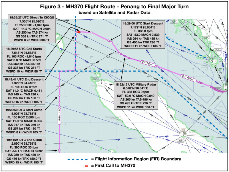
Researchers agree that the Inmarsat data confirm a southern route. Many independent researchers have attempted to more narrowly define the search area based on the Inmarsat data. Given the multitude of input assumptions and complexity of calculations, reasonable and intelligent people differ on their conclusions. For many, the greatest uncertainty is between the last radar contact at 18:22 near MEKAR and the first handshake at 19:41 UTC. This is what researchers Ulich, Godfrey, Iannello and Banks call the Final Major Turn.
Their analysis sought a route that was consistent with the 18:22 UTC radar point, BTO and BFO data, and normal performance specifications. They analyzed over 2,000 potential flight paths and found only one that satisfied all of their requirements. Regarding the Final Major Turn, after dropping from radar at 18:22, they believe the plane made several turns along airspace boundaries at low altitude to evade detection in what they call a “carefully planned and precisely executed diversion.”
Specifically, they believe the plane flew along airway N571 to mask itself amidst heavy traffic and give the appearance of a northwest route. To head south without being seen, they believe the plane turned off airway N571 after the last radar plot and started to slow down and descend beneath the intersecting airways. The plane followed the air border west until turning due south after the unsuccessful ground-to-air call at 18:39 UTC. It descended to about 10,000 ft, flying at 250 knots before cruising at a holding speed of 217 knots around 18:44 UTC. After passing BEDAX waypoint at 19:19 UTC and going further out of view, it began to climb to normal cruising altitude. It reached its highest altitude at 19:41 UTC (first handshake) and increased speed. After this point, the data indicates no significant turns, speed or altitude changes until fuel exhaustion in the South Indian Ocean.
Some have questioned the validity of the Inmarsat data, suggesting it could have been manipulated or fabricated. A different independent research team found that information “appears to have been edited out of the initial data logs released on or about 27 May 2014,” which limited the ability of independent researchers to analyze and validate the satellite data. An unredacted Inmarsat log file provided later is apparently still not the complete data set. This selective presentation and delay in sharing the full data could indicate fraud. Relationships between Inmarsat and the US government could suggest collusion.
However, researcher Ken St. Aubin, among many others, believes the data is authentic, having been logged in real time and containing anomalies that would likely have been scrubbed if fake. Additionally, the lack of data after disappearance appears to be consistent with the loss of ACARS and how the system was functioning at the time. That said, while the BTO and BFO data is likely authentic, it may have been spoofed to look like it was coming from MH370 when it wasn’t or hacked to generate false values.
The data can be real and also not be from the real MH370.
The witnesses tell a different story
Authorities investigating the disappearance dismissed the many witness accounts as “notoriously bad.” Researchers like Ken St. Aubin and Blaine Alan Gibson disagree. While there were false leads in the days and years following the disappearance, there are too many witnesses across too many areas reporting similar sightings to categorically exclude them from consideration.
That said, most of these accounts only confirm that they saw something—not that they saw MH370 or other planes involved in the operation. Unfortunately, none of the eyewitnesses produced any photos or videos of what they saw. But the sightings were unusual enough that many filed police reports.
Ken St. Aubin has compiled the witness testimony, building a timeline of accounts extending from the eastern coast of Malaysia to the Maldives. These accounts are summarized below.
The first sightings
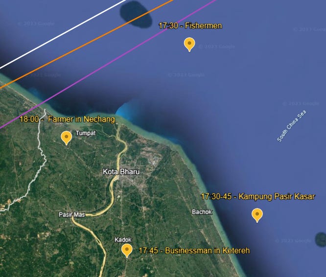
The earliest sightings are from fishermen and villagers who reported seeing a low-flying plane on the eastern coast of Malaysia between 17:30 and 18:00 UTC. As stated below, many of the witnesses reported that the plane was headed toward the South China Sea. This is the opposite direction shown in the civilian and military radar data. It also conflicts with independent analysis of the civilian radar data that estimated a true air speed of 507 knots and a standard altitude of 38,358 ft as it passed through Kota Bharu. Looking at the RMAF data, the aircraft descended from about 39,000 to 24,000 ft at 17:37 UTC before climbing to 47,500 ft by 17:45 UTC. It is not clear that would register as “low-flying,” nor does the westerly direction match witness accounts of it flying east out to sea.
While we can allow for some imprecision in the timing of the sightings, the plane could not be flying low on the east coast around 17:45 and 18:00 and be captured on radar at 17:52 UTC near Penang. It seems the only way these accounts could be describing the same plane is if witnesses were wrong about the direction, altitude, and in some cases, timing.
More likely, they didn’t see MH370. They saw a different plane.
If so, claims that MH370 made a rapid descent following its turn back to save passengers from fire or cabin depressurization or to evade radar are unsupported by the witness sightings. As explained below, the civilian radar of a plane at cruising altitude across the peninsula is likely the real MH370.
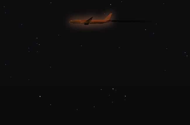
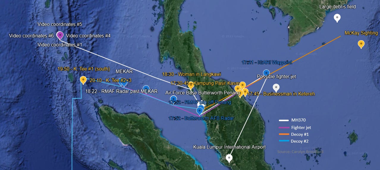
~ 17:20 UTC - The first witness testimony is from a group of eight people in the village of Marang near Kuala Terengganu. Around 17:20 UTC, when MH370 disappeared from radar, the men heard a strange loud explosion, though they did not see anything. St. Aubin believes it to be a sonic boom. It could have been caused by an intercepting military jet. In fact, FlightRadar24 video of MH370 shows a fast-flying, possibly hypersonic plane off the coast of Kuala Terrenganu that itself disappears from radar, along with another plane, a few minutes before MH370’s disappearance. Curiously, in a confluence of anomalous activity, at the video’s 46 second mark, a different plane is seen abruptly reversing direction, heading out to sea and then back toward land.
~ 17:30 UTC – In the first visual report, a fisherman about 10 miles off the coast of Kota Bharu reported seeing a “bright light streaking overhead.” He reported a plane flying “really low,” with lights “the size of a coconut.” He indicated it had turned north and out to sea, which was unusual for planes in that area.
At this same time, a pilot flying to Japan made radio contact with MH370 on an emergency frequency. Through static and interference, he heard mumbling at the other end. He said, “The voice on the other side could have been either Captain Zaharie or Fariq, but I was sure it was the copilot.” Then the connection was lost. He did not report anything unusual, believing, "If the plane was in trouble, we would have heard the pilot making the Mayday distress call. But I am sure that, like me, no one else up there heard it."
This account seems to discredit an article in The China Times stating that U.S. military stationed at the U-Tapao base in Thailand picked up an SOS signal from MH370 at 2:43 am (17:43 UTC). Allegedly, the pilot reported that the cabin was facing disintegration and they needed to make an emergency landing. Given that many early reports ended up being false, no one else reported hearing this SOS, and this SOS call was ignored by other media and omitted from the official report, it is potentially a fabricated story. Moreover, the official radar data extends to 18:22 UTC, with potential sightings before and after that, no emergency landing was attempted, and no verifiable debris field was found in that area, suggesting MH370 was not in its final moments at the time of the alleged SOS call.
~ 17:30 -17:45 UTC – A man in Kampung Pasir Kasar in Kota Bharu said he saw a low-flying plane with bright lights headed toward the sea. He thought there was something unusual about its direction and timing.
~ 17:45 UTC – A man 30 km south of Kota Bharu in Ketereh reported seeing the “bright white lights” of what he believed to be a low-flying plane descending fast and heading toward the South China Sea.
~ 18:00 UTC – A farmer in Nechang village near Tumpat said he saw a low flying plane heading toward Sri Tujoh Beach out to sea. He said he saw the MAS logo and thought there was a small fire on the tail fin.
~ 18:30 UTC – A woman in Langkawi saw a big plane flying low between Mount Raya and her house. It is the only plane she’s ever seen there. According to her, it was flying south to north.
There was also a report by oil rig worker Mike McKay, who was stationed off the coast of Vietnam. Sometime just after 17:00 UTC, McKay said he saw a burning object in the sky and watched it until the flames went out, thinking it might have crashed. Upon hearing about MH370, he thought that might have been what he saw. However, the timing and location doesn’t align for MH370, the decoy, or the possible military jet shown in the FlightRadar24 playback, suggesting he witnessed something else. Thus, given what we currently know, his account cannot be used to support a fire emergency or any other theory.
The Katherine Tee sightings
A woman named Katherine Tee received much attention after reporting that she saw a “what appeared to be an elongated plane glowing bright orange, with a trail of black smoke behind it” near the Nicobar Islands on the night MH370 went missing. Her account is also used to validate the fire emergency theory. However, as discussed below, the timing is problematic, as is her reliability as a witness, per her own admissions. This is not to discredit or defame her but to acknowledge the limitations of her testimony.
In Tee’s initial report from May 31, 2014 (over two months from the sighting), she noted that it seemed to be flying from north to south, much lower than other flights at an initial guessed altitude of 10,000 to 20,000 ft, though she admitted distance and altitude are difficult to determine at night at sea, and she later guessed 2,000 to 4,000 ft. Because she could clearly see the cockpit windows and hull, she thought it was “fairly close.” She noted she saw no navigation lights, passenger windows, or distinctive markings, though she later said the cockpit windows were bright yellow. She didn’t see any fire or flames—just a uniform orange glow around the plane. She doesn’t remember hearing any noise. She wondered if it was trying to land.
At the same time, Katherine also reported seeing two planes with normal navigation lights flying higher, in tandem, and heading the opposite direction (south to north). She later reported another plane flying south toward the Indian Ocean at high altitude about 20 minutes prior.
Presumably, Katherine Tee saw something unusual that night. However, there are several factors that make it difficult to confirm what she saw. First, her posts on the Cruisers Forum emphasized how stressed and emotionally distressed she was at the time, to the point of doubting her sanity. She didn’t know what day or time it was, save for being during her 2-6 AM night watch. She said, “I don’t have a friggin clue when it was.” Because she didn’t make a note at the time, she only placed herself in MH370’s possible path upon review of her GPS log.
She inferred the timing of her sighting at around 19:10 UTC based on an accidental gybe. She says:
In a nutshell, the accidental gybe during which I believe this happened only started shortly after 1910, and if I am correct, I could only have seen this plane when I was heading East. I have analysed our own GPS track yet again, and the engine would most likely have gone on somewhere between 1917 and 1919 (but definitely between 1915 and 1920). That means the sighting happened in the few minutes before that; so perhaps just a few minutes after your 1912 limit.
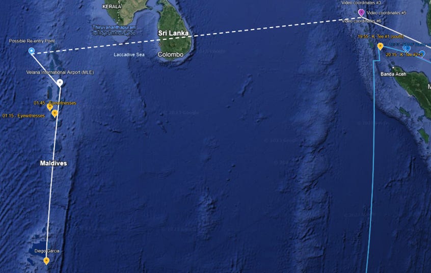
While their theory is not dependent on the Tee sighting, researchers Ulich, Godfrey, Iannello and Banks theorized that MH370 may have passed Kate Tee’s boat at 18:53 UTC while still flying low and slow on its journey south. As discussed below, this timing is problematic, making it unlikely that she saw the plane responsible for the Inmarsat data.

Tee’s time estimates have changed, starting as early as 18:40 UTC and extending to 19:25 UTC, adding uncertainty to when her sightings actually occurred. A larger issue is what time zone she was in since apparently her GPS log was recording in local time. She stated, “The GPS time is automatic, so it would have been UST [sic] +7, which is the same zone. That's where we were.” She was convinced they were in Thailand time. Yet her log places her northwest of Bandar Aceh and southeast of Great Nicobar Island, in the channel between Indonesia and the Nicobar Islands. This is UTC +6, not UTC +7. Thus, her 2 to 6 AM night watch on March 8th was 20:00 to 00:00 UTC on March 7, putting the range of sighting times at 19:40 to 20:25 UTC. And whether 18:40 or 19:40 UTC, both times are before the 2 a.m. start of her night watch.
In addition to timing, several other details of her story changed or emerged as time passed. For example, when discussing the cockpit windows in July 2014, she said she couldn’t remember if they were light or dark. In 2017, she said they were bright yellow. She claims she has not changed her story to fit the various theories presented to her, but the numerous changes in her account raise doubts as to the reliability of her testimony.
The only somewhat solid information seems to be that to the west of her boat she saw a glowing orange plane flying low on a southbound track and that there were two other planes with normal navigation lights flying higher at the same time in the opposite direction (northbound).
According to one researcher’s look at flight radar, there were no matching planes in the area, though the time discrepancy could be an issue. Assuming the proper view, that the two high-flying planes did not appear on radar could suggest they were military. This is perhaps corroborated by the lack of established north-south airways at her boat’s location.
Morning sightings in the Maldives
On the morning of March 8th, multiple witnesses on the island of Kudahudvadhoo in the Maldives reported seeing and/or hearing a low-flying passenger jet. The times ranged from 6:15 to 6:30 a.m. local time or 1:15 to 1:30 UTC, approximately 8 hours after MH370 dropped from radar. According to reports by independent researcher Blaine Gibson, who traveled to the Maldives to interview locals, “The plane approached from the northwest, and turned upon reaching the island to head almost due south.” Many commented on the blue and red markings on the plane. There were no signs of a fire. Unlike the other sightings, there is no radar data to compare it to, as the Maldives do not have primary radar. A sample of the reports are presented below.

~ 1:15 UTC – A court employee, Abdu Rasheed, said a plane approached him at 6:15 a.m. from the northwest and upon reaching the southwest corner executed a deliberate turn heading South/SE. He said it was a “mostly white plane with a long row of windows and a red stripe.” According to Gibson, when shown pictures of different planes, Rasheed positively identified MH370 as the plane he saw.
~ 1:15 UTC – Per Gibson’s report, Ahmed Shiyam looked up when he heard a very loud noise and saw a large jet, noting the windows, two jet engines, and bright white colors. The sun was shining brightly so he did not notice the other colors. He did not see any smoke or fire, though there was steam coming out of both engines. The plane flew away from him level and steady, neither climbing nor descending. Like Rasheed, when showed pictures of MH370, he positively identified it.
~ 1:15 UTC – East of Rasheed, Ibrahim Nasir heard a very loud sound while jogging. According to Gibson’s report, the plane was coming very fast and above him, crossing Kudahuvadhoo. The bottom of the plane was silver and he saw a line of red and blue. Again, when showed pictures, he positively identified MH370.
~ 1:45 UTC - Before 7 a.m. local time (2:00 UTC), a second group of eyewitnesses on the next southern atoll, Gaadhiffushi Island, reported seeing a large low-flying plane with blue markings circling overhead before heading south.
These sightings were not reported in the media until Day 12. Like the Malaysian government, the Maldives government kept changing their story. According to Gibson, “the government first claimed there was ‘no plane,’ then the plane was a ‘private jet,’ then fifteen months later a ‘domestic propeller plane flight,’ then back to ‘no plane,’ then finally to say it cannot be discussed due to ‘national security.’” All the witnesses were emphatic that it was a large jet plane, not a propeller flight. Additionally, flight logs showed no propeller flight that day.
Though there isn’t consensus, a professional pilot told Gibson that his fuel calculations showed MH370 could have still been flying at the time of the Maldives sightings, though it would have had to take a direct route from the Nicobar Islands and been nearly out of fuel. For this route to be right, the Inmarsat data would have to be wrong, or from a different plane. Or as discussed below, fuel may have been a moot point.
The leaked videos of a vanishing plane
Shortly after MH370’s disappearance, two videos appeared on YouTube courtesy of anonymous user RegicideAnon showing a plane interacting with orbs or spheres before abruptly vanishing with a flash. While no one has yet claimed the original videos, there is substantial evidence that they are authentic and were leaked by a military insider who knew exactly what he or she was doing. The plane in the video is believed to be MH370 due to a matching silhouette and color pattern and coordinates that place the videos in the assumed MH370 flight path.
Working with visual effects (VFX)/computer generated imagery (CGI) experts, researcher Ashton Forbes concluded that it is extremely unlikely, if not impossible, that the videos could be faked in the time between the event and the videos posting using current technology and publicly available information. Considering the received and post date of the satellite video, there was a minimum of 4 days (if we trust RegicideAnon’s original receipt date) and maximum of 72 days to create the first video, unless these videos were faked in advance. That seems unlikely given that the mission likely emerged in the days or couple of weeks before execution.
To fake the video, the creator would need the following knowledge to develop a logically consistent video reflective of key data points (info from Forbes):
The turn radius of a Boeing 777 at a certain altitude and in descent
Weather and cloud cover in the Nicobar Islands
The satellites or drones in use and their capabilities
Accurate coordinate shifts relative to the location
Presentation of classified military software systems and associated hardware
Frame rate difference created by capturing satellite footage on a Citrix session
With this knowledge, the creator would need the technical skills, computing power, resources, and time to produce the video, including how to:
Create and light realistic volumetric clouds
Accurately animate camera views
Animate coordinate shifts
Animate the spheres and sphere trails
Accurately create the exhaust/smoke trailing the plane
Create 3D stereoscopic imagery
The creator(s) would also need to be able to match the videos to one another on key parameters, including the plane, clouds, and other points listed above. To pull this all together into convincing videos, the creator must have exceptional VFX skills surpassing what we saw in Top Gun: Maverick. The timeframe to accomplish this would have been between 89 and 96 days, which is far shorter than what industry insiders say is possible.
Some have suggested that the video is real but the event at the end is fabricated, meaning the spheres were legitimate but the disappearance isn’t. The potential reason given for fabricating the end was to discredit the entire video by showing that elements of it were faked. As noted above, the evidence that the disappearance was faked is not compelling. It also isn’t clear why the videos would be leaked at all if the point was to hide this technology. Further, the interaction with the spheres also defies known physics and raises important questions about who designed and sent the spheres, making the video just as incredible without the disappearance.
For a deeper dive into the authenticity of the videos, read the article below.

The first stereoscopic video
On May 19, approximately two months after MH370 disappeared, RegicideAnon posted a video from a “protected” source. The original post states it was received on March 12, 2014, just four days after the plane’s disappearance. Researchers have surmised that the delay between receipt and posting was due to RegicideAnon’s vetting, validation, and decision-making process. Because RegicideAnon’s identity is unknown, we have no insight into the video analysis, nor confirmation of the receipt date or origin. The sensitive and classified nature of the video explains the anonymity around it, including no direct claim of being MH370 (other than a #mh370 hashtag in his Twitter post). We do not know if RegicideAnon is the direct recipient of the leaked videos or is posting from another source, such as a private forum or the dark web. Reportedly, higher quality versions appeared on the internet weeks later, suggesting the RegicideAnon video is not the original.
The video, with a duration of 1 minute 8 seconds, shows two side-by-side videos of a plane making a wide turn. It is surrounded one at a time by three spherical objects moving about 10 times faster than the plane (estimated at Mach3 speed). The objects circle the plane in formation before executing a vertical pattern around it—defying gravity. As reported by Ashton Forbes, work by a fellow researcher on Reddit, u/Journey_Guide, has shown that there is a harmonic pattern to the spheres, which could provide a clue to their function. The spheres surround the plane for 40 seconds and seemingly converge on the plane before they all disappear.
Forbes believes this first video was taken by a pair of Naval Ocean Surveillance System satellites capable of stereoscopic imaging. The research team narrowed in on a specific satellite, USA-229, by matching the coordinates shown in the bottom left of the video (near the Nicobar Islands) and the deduced flight path to the satellites within range at that assumed time (18:40 UTC) with the right operational capabilities. Being visible on Earth, hobbyist astronomers have catalogued the historical orbits and trajectories of these satellites, which are used to intercept signals to locate and track moving vehicles.
However, there is not consensus that the side-by-side video came from USA-229. Researcher Ken St. Aubin claims, “A pair of synchronous orbiting satellites are not the only way to have stereoscopic IR video.” He also disputes that USA-229 was positioned at the correct angle to capture the video since his analysis shows a perspective looking from west to east and the satellite’s coordinates place it looking east to west.
Given the error in timezone for Tee’s sighting, used to timestamp the videos, USA-229 might not have been in the right place at the right time. Instead, the video could have been filmed by a drone with 2 FLIR pods transmitting video via relay satellite NROL-22. It is possible the US dispatched multiple drones and filmed from various angles and with varying capabilities. These could have been the two high-flying, tandem planes seen by Katherine Tee heading north toward the video coordinates.
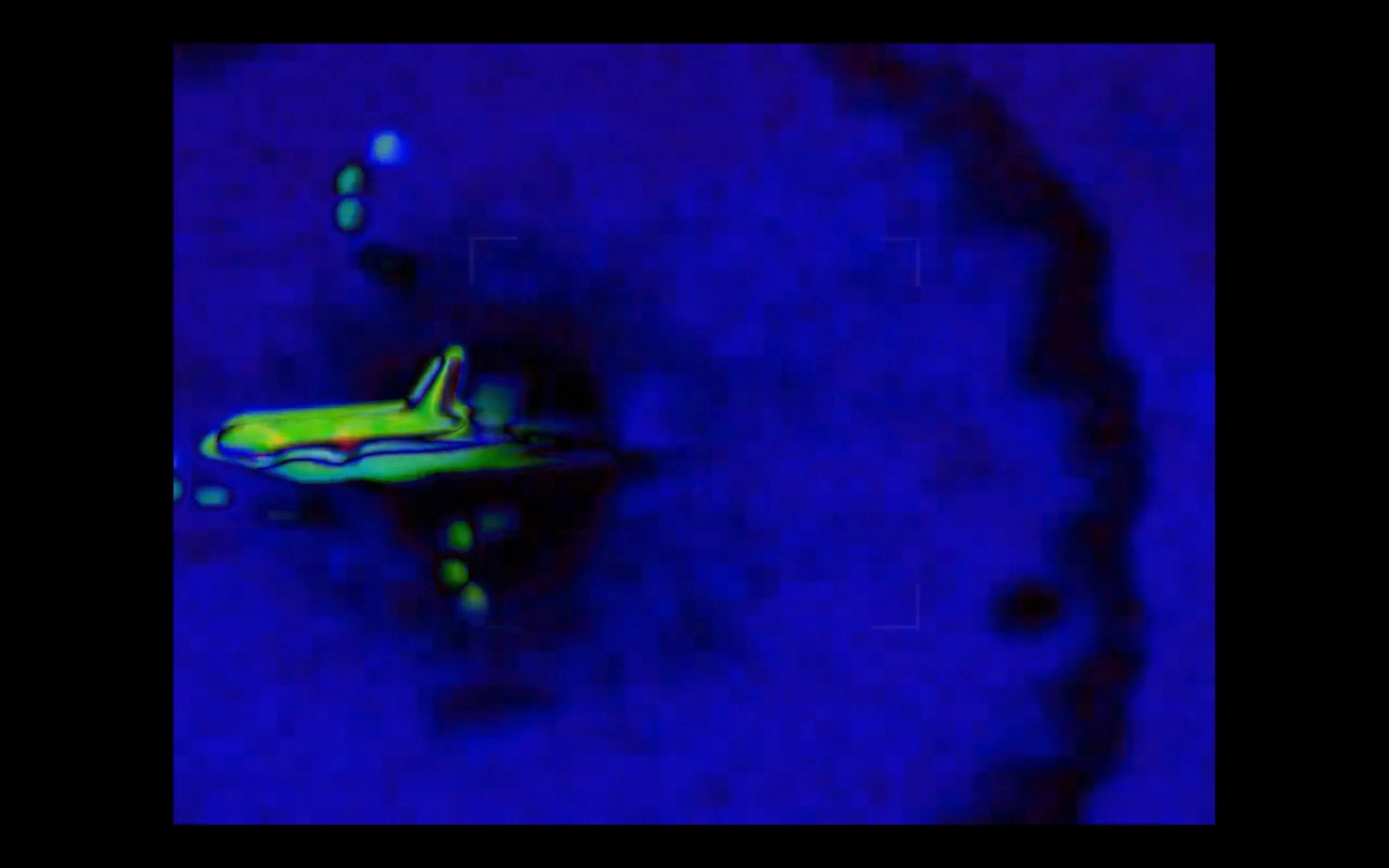
Forbes has shared evidence that the video was a direct screen recording by someone logged into the US spy database via a Citrix remote session. The operator moves the screen to keep the objects in view, showing an intent to capture this incredible event. Researchers identified the system being used as likely the Pluraview 3D desktop with Stealth or Softmouse3D controllers.
The second thermal video
RegicideAnon posted a second video on June 12, 2014, with a receipt date of June 5, 2014. It is thought that this second video with enhanced information was released due to a lack of traction from the first video and a desire for additional proof to be shared.
This video is drone footage with a color thermal layer added that reveals greater detail, such as dark trails in front of the spheres and the cold signature of the zap, which rules out an explosion. Forbes reported that the color layer was manually added by the leaker using the electro-IR camera’s onboard software. Forbes also notes that the Heads Up Display (HUD) data was removed, thereby minimizing the classified data conferred in the leak. This suggests the leaker was trained in the system and knew the potential implications of what was shared.
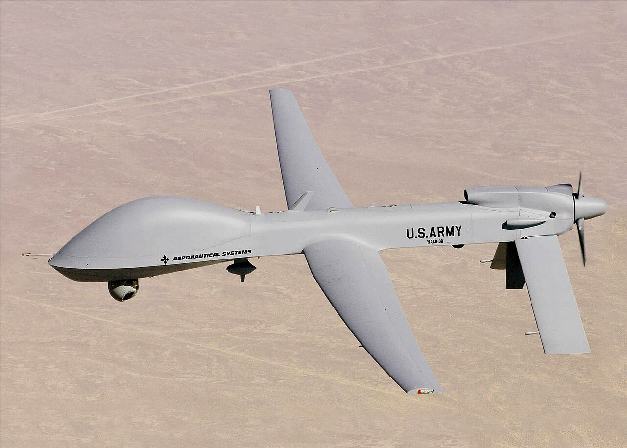
The drone was identified as the MQ-1C Gray Eagle based on its frame and payload. According to Wikipedia, the MQ-1C Gray Eagle is a “medium-altitude, long-endurance (MALE) unmanned aircraft system (UAS)” developed by General Atomics Aeronautical Systems for the United States Army. While the drone is much slower than the 777, the drone could have been dispatched from a nearby US military installation to intercept and film the event.
The implications
Assuming the videos are real and showing MH370, they prove that the US was watching MH370 as it diverted from its flight path. The drones must have been stationed nearby and had enough notice to be deployed in time to witness the events in the video.
This suggests the US knew where to be ahead of time, which lends support to the fighter jet theory and the supposition that this was planned and executed by the US.
Additionally, while it is mind-bending to see an object vanish or dematerialize, physics says it is possible. With what we currently understand about wormholes and the quantum realm, teleportation is a real phenomenon that can be explained. As Salvatore Pais stated, “This is a new perspective on old physics.” Forbes points to a handful of scientific papers that support this technology and continues to work with next generation physicists like Salvatore Pais and Dave Rossi, who have the equations, patents, and sophisticated understanding of energy and matter to explain how teleportation is possible. According to Pais, what he is describing is the “tearing apart locally of the space-time fabric at a quantum level.”
Additionally, whistleblower testimony, such as that provided by government insider David Grusch, has alleged the existence of a secret US reverse engineering program to recreate advanced alien technologies, of which this may be one. Grusch has stated, with Department of Defense permission, that the US is in possession of at least 10 (“double digits”) recovered non-human crafts, the locations of which he has offered to disclose to lawmakers in a classified setting. Recent legislation is aimed at reclaiming these craft from defense contractors. Decades of UFO sightings across the world also support the idea that we are being visited by advanced civilizations with technology that far surpasses our current commercial capabilities.
Thus, teleportation technology (or super-luminal speed event or whatever the precise terminology may be) is not so far-fetched as we might think. Nor is free energy.
But what was so important about MH370 to justify deploying this technology in this way?
Who and what was onboard
Why would MH370 be the target of such an extraordinary plot of deception? What was the motive?
As explored in previous articles, the only logical conclusion is that there was something and/or someone on board of extremely high value to one or more parties.
The presumption is that it was top secret advanced technology, likely with military applications, that would be damaging to US national security should it fall into the wrong hands.
This theory is potentially supported by the presence of 20 Freescale Semiconductor employees on board, who may have been in possession of the material and/or have the specialized expertise to reverse engineer stolen technology.
The cargo
Much attention has been paid to the potential for a fire from the lithium-ion batteries on board. While there are isolated reports of seeing small flames or burning or glowing objects, there is no solid evidence that a fire emergency was the driver behind MH370’s disappearance.
First, the official report found no conclusive evidence of a fire, nor could they recreate conditions that would start a fire. Given that a fire would be a convenient explanation, if there was support for this, it is unclear why it would not be revealed. Second, it is not conclusive that the heat signature shown in the thermal video is in the rear cabin where the batteries were stored, nor that it is anything more than hot air from the right engine. Third, the only witness who reported seeing a burning object, Mike McKay, was not positioned where he could have seen MH370, or even if he was, that he could discern what he was seeing.
It is also questionable that Katherine Tee saw MH370. Even if she did, she reported no flames or fire—just a glow, which could possibly be explained by the effect of halon fire extinguishers, but also by other phenomenon. It is also unclear that what she classified as black smoke was truly that. Additionally, what has been called smoke in the leaked videos is likely just a contrail, as there is no evidence MH370 was flying low at the time of teleportation and the trails don’t behave like smoke in the atmosphere.
Finally, there are too many “coincidences” surrounding the timing of the blackout periods and restoration of communications to claim an accident. That an intense battery fire would cause just the SATCOM to go down but not destroy it, such that it could be rebooted (yet without its critical data link) is unlikely, as is a scenario where a fire capable of that damage would enable the plane to continue flying. We can potentially explain the SATCOM reboot as coming from the decoy (as discussed below), but too many other pieces of evidence would need to be declared wrong or fake for a fire emergency to be the most likely reason for the plane to lose communications.
This is not to say that the batteries or something planted within the batteries could not have caused a fire. We know transporting lithium-ion batteries is dangerous and fires do happen. If there was a fire, it was likely one of the many contingency plans and not a true accident or driver. The batteries may be a smokescreen.
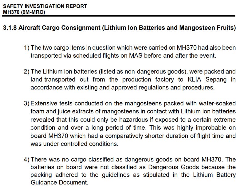
Despite having the cargo manifest, we likely don’t have the full picture of what was on that plane. The content descriptions are vague and the security screening was cursory. As noted in the official report, the battery cargo was visually inspected but it “did not involve the breaking down of the cargo” nor screening via x-ray (SIR, p.424). Whatever was so valuable as to justify this operation was not disclosed.

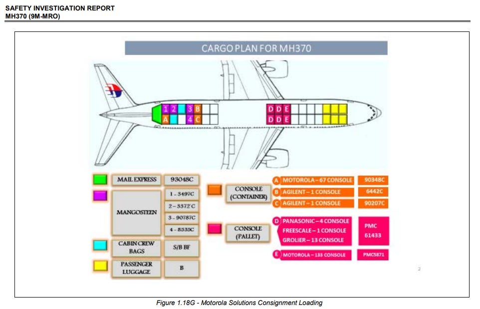
French investigators claim 89 kg of mystery cargo was added to the flight last minute and didn’t appear on the flight manifest until after take-off. St. Aubin made the connection to classified military hardware stolen off a U.S. container ship—the Maersk Alabama—in the Seychelles just two weeks earlier in February 2014. This is the same ship involved in a 2009 hijacking by Somali pirates, which inspired the Tom Hanks movie, Captain Phillips. Adding to the mystery are the deaths of the two ex-Navy Seals hired to guard the cargo. Their friends and family did not believe the cover story of drug overdose and demanded an investigation into what they believe was foul play.
The Seychelles are home to a US drone base established in 2009 for surveillance and reconnaissance missions in the Indian Ocean region. It is possible that the cargo stolen from the container ship was related to highly coveted US drone technology, and was in the process of being smuggled to China. As mentioned above, it is also possible that the Freescale Semiconductor employees had been compromised, involved in the operation, and were transporting sensitive classified material to China on laptops, flash drives, and/or in cargo, which was reportedly carrying 6 kg of semiconductor chips.
For more information on the cargo, read the article below.

The Freescale Employees
According to the official Safety Investigation Report, “a total of 227 passengers (including 3 children and 2 infants) were on board with the majority of them from China [153 people], followed by Malaysia and other citizens from different countries” (SIR, p.264). The plane was at 80 percent capacity.
A few articles mentioned that there were 20 employees of the US-based, multinational technology company, Freescale Semiconductor, now part of NXP Semiconductors. Reuters reported that none of the most senior executives were on board. The passengers were primarily engineers and other technical experts. Twelve were from Malaysia and eight were from China. According to the vice president of global communications and investor relations, Mitch Haws, “These were people with a lot of experience and technical background, and they were very important people.”
This group of passengers caught the attention of researchers for three primary reasons: (1) Most companies have risk management policies that limit the number of key personnel or critical teams on the same flight, raising suspicion of why so many were traveling together, (2) Freescale’s technology was used in many military electronics applications, such as “avionics, radar, and electronic warfare,” and may have been integral to top secret projects, and (3) the company was sold a year after the plane disappeared, which could speak to possible motives, should the disappearance have been planned.
Freescale Semiconductors became an independent company in 2004 after 50 years of being part of Motorola. Motorola received seed funding from DARPA for the development of some of the company's early research projects and initiatives, particularly in the field of telecommunications and mobile technology. As a stand-alone company, Freescale announced a further commitment to support the US military sector, identifying the defense industry as a preferred growth area. As such, Freescale was actively developing electronic warfare products for military applications. The Express reported:
Avoiding radar via ‘cloaking technology’ has long been one of the objectives of the defence industry and Freescale has been active developing chips for military radar…Last June it announced it was creating a team of specialists dedicated to producing ‘radio frequency power products’ for the defence industry. And on March 3, it announced it was releasing 11 of these new gadgets for use in ‘high frequency, VHF and low-band UHF radar and radio communications’.
Freescale’s March 3, 2014 press release stated, “Freescale now offers the level of support provided in other markets to U.S. defense systems customers, enabling them to optimize the performance of these RF devices for radar, military communications and electronic warfare applications.” Freescale could have been engaged in advanced R&D, perhaps even as a contractor for black budget projects like the reverse engineering of non-human technologies. Given that Freescale was a supplier to the military, highly advanced technology would likely be developed with the cooperation or at the direction of the US government.
As stated by the Center for Strategic and International Studies:
Ensuring U.S. leadership in semiconductor technology and securing the integrity of the value chains that design, manufacture, package, and distribute these chips are perhaps the preeminent economic and national security concerns of the modern era.
In October 2022, a comprehensive US Bureau of Industry and Security rule banned the sale of semiconductor equipment to China and restricted “US persons” from supporting the development or production of semiconductor and related technologies that could be used by China for weapons of mass destruction and advanced military applications. It closed loopholes allowing export for civilian purposes, recognizing that China has a military-civil fusion that could easily divert technology for military uses. Thus, this 2022 rule is a reaction to a known problem, representing an “urgent need” to protect America’s semiconductor and supercomputer leadership.
Additionally, there have been several cases of Chinese nationals stealing sensitive information from US companies. One example is Yu Long, who “admitted to stealing and exploiting highly sensitive military technology and documents, knowing his theft would benefit China’s defense industry.” The US has stated that, “The CCP acquires others’ research by co-opting Chinese nationals, secretly paying foreign scientists to recreate research in the People’s Republic of China (PRC), and sending military officers abroad disguised as civilians to steal technology and information to advance the PRC’s military and economic development goals.” Clearly, the Chinese want what we have and are willing to pay dearly for it. Currently, the best chips in China are considered to be several generations behind American and Taiwanese chips.
Semiconductor technology has long been regarded as highly sensitive and essential to competitiveness and security. That technology alone might have been enough to warrant an extreme measure of protection. But what if there was something even more valuable than that, like breakthroughs in superconducting?
If the US became aware that someone(s) on board planned to sell or leak top secret information or materials or was otherwise a national security risk, it might take extraordinary action to protect it.
For more information on the passengers, read the article below.

The pilot and crew
In the search for answers, investigators vetted everyone on the plane to see if there were any terrorist connections or other red flags. Initially, two Iranian men flying on stolen passports raised suspicion, but were quickly exonerated as authorities found no link to terrorist groups or activities. Seems they were just two young men headed to Europe for a chance at a better life.
With all passengers cleared of suspicion, attention shifted to the flight crew. The flight was piloted by Malaysian national, Captain Zaharie Ahmad Shah. He was an experienced pilot with 18,365 hours of flight time, having joined Malaysia Airlines in 1981. The first officer, Fariq Abdul Hamid, also a Malaysian, joined Malaysia Airlines in 2007 and had total flying hours of 2,763 hours.

Captain Shah came into the crosshairs as evidence pointed to deliberate action, including several manual and skillful actions like the turn back and transponder switch off. It seemed someone was controlling the plane at least until the last radar plot at 18:22 UTC. Investigators raided Captain Shah’s home and seized his flight simulator for clues. The FBI came to retrieve and analyze recently deleted data. They reportedly found simulations to five destinations in and around the South Indian Ocean, including India, the Maldives, and Diego Garcia.
Theories emerged about a pilot suicide mission. However, there were no indications of mental, marital, or money issues or other motivations supporting mass suicide. Those who knew him said he was a kind and unassuming man with a wife and three kids who was passionate about flying. He was just a few years from retirement. While there were rumors of his infidelity and proof of a bizarre obsession with young twin models, including over 90 DMs to the pair, such behavior is not indicative of an international hijacker.
Others looked at Shah’s “fanatical” political views with suspicion, namely his connection to Malaysian opposition leader Anwar Ibrahim of the People’s Justice Party. While the media played this up as extremism, Anwar Ibrahim was “a nonviolent man who supports a pluralistic and democratic Malaysia.” Shah supported an alternative to a corrupt and authoritarian regime. He might have been an activist and rebel but that doesn’t de facto make him a terrorist. Nor is it clear how murdering a plane of mostly Chinese citizens would be an effective protest against Malaysia’s political system.
Neither the suicide or martyrdom theory make sense.
On Day 15, the Malaysian government concluded it was hijacking. Given they found no evidence of a struggle or of anyone else commandeering the plane, investigators blamed Shah. The data seemed to support it. The person controlling the plane clearly had extensive flying expertise and knowledge of a 777. Additionally, according to analysis by Victor Iannello, there wasn’t enough time for a third party to enter the cockpit and seize control. He states that, “the maximum time available to disable the transponder and divert the aircraft was 64 seconds.”
If Captain Shah played a part in what happened, was it as a hostage or as an accomplice?
Interestingly, repeated attempts by Iannello over the last several years, as recent as May 2023, to obtain information about Captain Shah and MH370 via FOIA requests continue to be denied, due to “a pending or prospective law enforcement proceeding relevant to these responsive records.” Similar attempts by Ghyslain Wattrelos, whose wife and two children were on board, to get information from US sources were repeatedly denied or delayed, suggesting, again, that the US knows far more than it has revealed.
It may even suggest that Captain Shah is not being investigated as a criminal but protected as one.
The CIA has a sordid history of grooming, manipulating, and/or blackmailing people to carry out their attacks and crimes. Could Captain Shah have been convinced or coerced into cooperating with their plan through promises or threats?
It is hard to imagine what would entice such a man to voluntarily walk away from his family, career, and freedom, though it is said that everyone has a price, whether that is money or some other dream. Perhaps he was promised a chance to be a hero. Perhaps he had to choose between a new life or what would become the shame and wreckage of his old one.
We do not know whether he was aware of what was to come before he boarded the plane. On the one hand, investigators detected no abnormal or anxious behavior, no anomalies in flight or fuel planning, or any other sign that he was stressed or preparing for what would happen. On the other hand, the flight simulator had runs to what may have been destination airports, like Male and Diego Garcia. That said, as a flight enthusiast, there is nothing inherently suspicious in playing with different routes. Perhaps it is more suspicious that the FBI seized the equipment. Was it that they alone had the requisite expertise or were they seeking control of evidence to facilitate a cover-up?
While the timing is extremely tight for someone to break into the cockpit and take control, it remains a possibility that the flight crew, and specifically the pilot, are completely innocent. It would not be difficult for a highly trained team of state assets to board the plane as passengers, maintenance crew, or stowaways and hide until their moment of action. Such skilled actors could pull this off without any cooperation from the pilot. To underestimate the state’s capabilities is folly.
Putting it all together into a unified theory
“The whole secret lies in confusing the enemy, so that he cannot fathom our real intent.”
Sun Tzu, The Art of War
The journey of explaining what happened to MH370 has been one of confusion and contradictions. The investigation was characterized by many misdirections, reversals, denials, and outright lies. While the hard facts are few and far between, the truth is hiding among the fragments, waiting like puzzle pieces to be fit together.
Past efforts to tell the true story of MH370 have often suffered from the fallacy of saying one piece of evidence can’t be true because it conflicts with another. For example, some say the Inmarsat data can’t be real because of the eyewitness sightings in the Maldives or vice versa. Additionally, many of the researchers, though brilliant in their fields, have fallen victim to conventional and limited thinking. Others have ignored key data points inconvenient to their theory.
What if all of the evidence is true? What theory emerges then?
MH370 is escorted in the turn back
Malaysia Airlines flight 370 took off from Kuala Lumpur with all systems intact. It climbed and cruised across the Malaysian peninsula to the IGARI waypoint, where, at 17:21 UTC, it dropped from radar. At this time, as MH370 crossed jurisdictional airspace, the transponders and SATCOM system were disabled and air traffic control was minding other flights. This is the first blackout period, which allows the plane to go missing.
The next convergence of events is around 17:30 to 17:45 UTC. Military and civilian radar show what are likely two planes turning back over the peninsula toward the Straits of Malacca. The official RMAF radar data shows a plane flying at altitudes between 24,450 and 47,500 ft and speeds of 451 to 571 knots from 17:21 to 17:45 UTC. Analysis of the spotty civilian radar results in a best estimate of standard altitude of 38,358 ft and true air speed of 507 knots as the aircraft cruised through Kota Bharu radar coverage around 17:30-45 UTC.
We also have Thai military radar reports of a plane flying back toward Kuala Lumpur and turning right toward Butterworth AFB. At the same time, eyewitnesses on Malaysia’s east coast report seeing a low-flying jumbo jet headed in the opposite direction out to sea.
For this all to be true, MH370 turned back after the IGARI waypoint, as stated in the official narrative. This is the plane seen appearing and disappearing in the civilian radar, potentially using radar cloaking technology or affected by AWACs in the region.
The plane was escorted by the fighter jet seen in the official RMAF radar and potentially in the FlightRadar24 video off the coast of Kuala Terrenganu, which shows a plane accelerating at potentially hypersonic speeds before cruising and also dropping from radar in the moments before MH370’s disappearance. Interestingly, another nearby plane disappears from the radar playback a few moments before, potentially indicating these were military craft turning off their transponders or otherwise masking their presence.
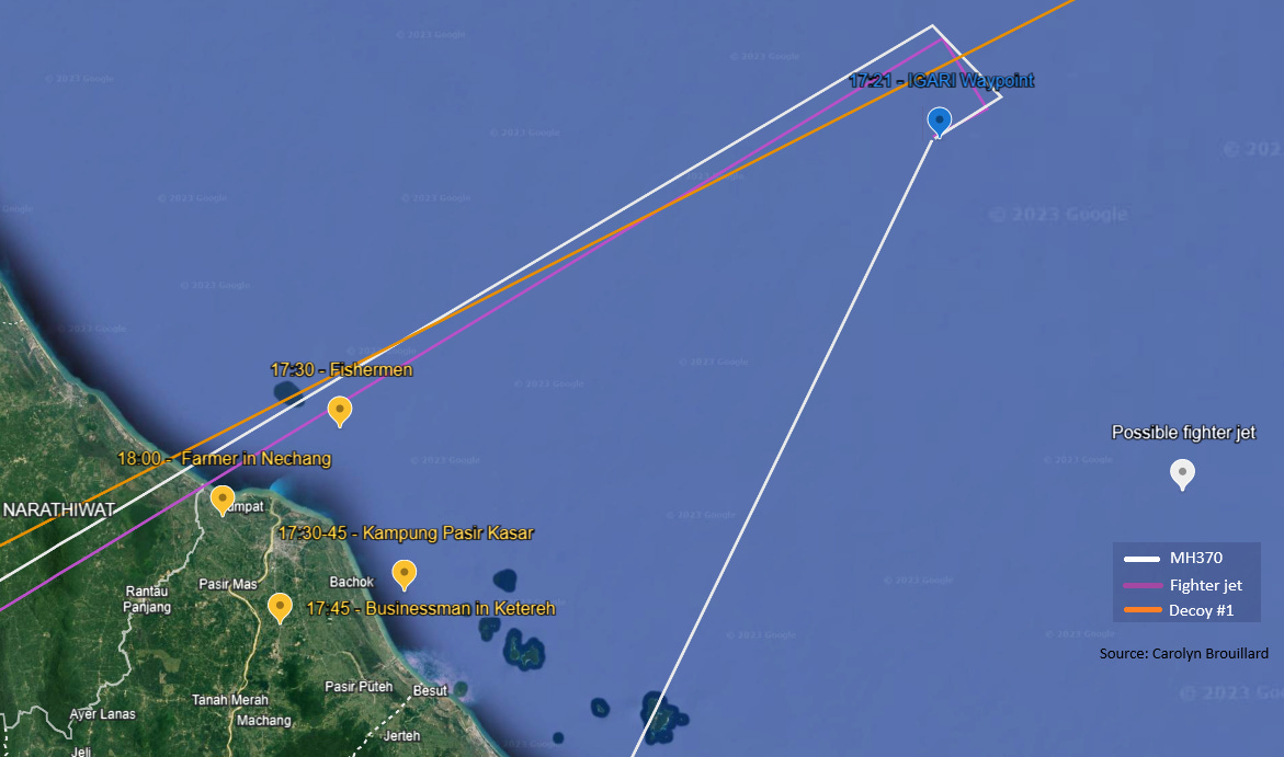
The villagers near Kota Bharu saw a decoy 777, likely launched from Butterworth AFB, headed out to the China Sea/ Gulf of Thailand toward MH370’s last known location. This is potentially corroborated by a March 10th report by a Cathay Pacific flight crew en route to Kuala Lumpur from Hong Kong of a large debris field off the coast of Vietnam. This was echoed in several other reports, including the presence of oil slicks in the area.
However, despite multiple reports from flight crews and volunteers scouring satellite footage, an extensive six-day search involving many countries reportedly turned up no solid evidence of a crash. Nor was a claim by Chinese professors at the Earthquakes and Earth Interior Physics Laboratory of a slight subsea incident in the non-seismic area between Malaysia and Vietnam at 2:55:06 a.m. local time on March 8, an hour and a half after the last contact with flight MH370, found to be significant. Ultimately, all claims of wreckage in the waters off Thailand and Vietnam were dismissed as not coming from MH370 or simply ignored.

This decoy and potential debris in the China Sea may have been intended to confuse people and create chaos, as well as allow time to cover their tracks by focusing search efforts east instead of west. It may also have been a contingency, where they could claim wreckage off the coast of Vietnam if they needed to divert attention away from the true location of MH370.
Despite some evidence of a crash in the China Sea, the fate of the first decoy is still an open question. It is possible there was a controlled ditching in the ocean, with the Navy recovering much of the debris. It is also possible the plane landed somewhere under cover.
Rendezvous around 17:52 UTC at Butterworth Air Force Base
The next point of convergence is around 17:52 UTC near Penang and the Butterworth AFB. RMAF radar has the fighter jet about 10nm south of Penang Island. The last primary civilian radar ping has MH370 about 6nm south of Penang Island. Despite discrepancies in location, speed, and altitude, the official report represents these two data sets as both coming from MH370.

It is possible that MH370 landed at Butterworth in the minutes after 17:52 UTC, when the civilian radar data stopped, matching the right turn to Butterworth noted by the Thai military. The passengers were unloaded and either placed on another plane or transferred to a nearby ship, perhaps parked in the waters off Pulau Perak, shielded from view. They may also have been held at the base for some period of time before being transported somewhere else. This could explain why one family member received a call from her missing father (unfortunately it stopped ringing before she answered it) and several other phones rang (though were not answered) when called by relatives.
Alternately, the passengers could have remained on board the real MH370 as it headed toward the Nicobar Islands. At least one remote viewing account, posted before and without mention of the leaked videos, seems to describe the passengers being on the plane when it encounters an intense electrical disturbance, resulting in a plasma look to the sky, followed by loud rumbling, a flash of light, and an eerie calm. Then the plane is gone. She feels the involvement of extraterrestrials in some way. It sounds a lot like the teleportation event portrayed in the videos.
While it is theoretically possible to teleport people, the more likely scenario is that the passengers were not on board MH370 when it disappeared.
There were strategic and logistical reasons to separate the people from the cargo.
For example, this would limit what the passengers see and know, allow them to be sent to different destinations, and potentially expedite the recovery of the classified material, which was likely the highest priority. Thus, for the sake of risk, time, and other considerations, the working hypothesis is that the secret cargo was left on MH370 to be transported to its final destination, potentially on a remotely controlled, unmanned craft, as could be possible using Boeing’s Uninterruptable Auto-Pilot (BUAP) or other advanced drone technology.
After leaving Butterworth, MH370 could have flown north, where it was seen flying low and from south to north by the woman in Langkawi around 18:30 UTC. By flying low, it could evade radar.
Meanwhile, according to the RMAF data in the official report, the aircraft believed to be a fighter jet drops off radar at 18:01 UTC following a sharp descent. This drop from civilian and military radar creates another blackout where the operatives have cover to move people and cargo and execute the next phase of the operation. This could be the period when a second decoy 777 departs Butterworth and heads toward the Nicobar Islands before making its final southern turn.
The southern decoy’s journey to the Indian Ocean
Given that the SATCOM was restored without ACARS, the decoy’s SDU could have been programmed to mimic MH370’s AES ID code and produce the Inmarsat data, thus giving the illusion of continuity of data from MH370. In this scenario, the final pings, interpreted to show a plane flying west toward the Nicobar Islands before turning south to the South Indian Ocean could be authentic. They just aren’t from the real MH370.
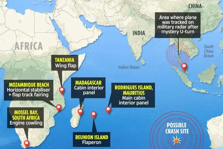
The decoy is a critical part of the cover-up. First, satellite communications on board the decoy create and seemingly validate the official narrative that the plane crashed in the South Indian Ocean after running out of fuel. It directs search efforts to that remote part of the world, diverting attention from MH370’s actual destination. Second, a decoy potentially provides physical debris that can be said to support the official story and end speculation. In fact, thanks to media messaging, most people believe MH370 was found, despite never having recovered the confirmed full wreckage, bodies, or personal effects of anyone on board.
The first piece of debris attributed to MH370—a plane’s right flaperon—was found in July 2015 on Reunion Island, almost 2,300 miles from the search area in the Indian Ocean. Twenty-six suspected pieces were recovered in Tanzania, Mozambique, South Africa, Madagascar and Mauritius over the next 18 months. Of these items, only three were confirmed as coming from 9M-MRO, with several others almost certain or likely coming from the plane. Even if all from the plane, they represent a small fraction of the total material.
Not everyone was convinced that the debris was from MH370. Florence de Changy is among them. According to de Changy, an inside source said the flaperon was missing its ID plate, which only could have come off if purposefully dismantled. Also suspicious was the uncanny ability of researcher Blaine Gibson to find pieces of the plane when so many others did not. It is possible that his enthusiasm for finding the plane was exploited by state actors, who used him to uncover materials they planted.
Given that the earliest debris was found over a year from disappearance, it is possible the debris was from a dismantled 9M-MRO or one of the decoys, particularly the southern decoy. Researcher St. Aubin discovered an old MAS 777 registered as 9M-MRI that was listed as purchased by GA Telesis in 2013, stored in 2014, and, according to St. Aubin, scrapped in 2015. The plane could have been outfitted with known technology that allows for remote control. Further, St. Aubin posits this decoy was seen by multiple witnesses flying low and apparently empty in Western Australia hours after the Inmarsat data stopped. One witness mentioned it appeared to be heading out to sea, perhaps to be ditched further south and east in the South Indian Ocean. It is also possible that the southern decoy landed in Australia to be recovered for planted debris.
The implication is that isolated debris is not definitive proof that the plane went down. It would not have been difficult to plant debris, particularly from a decoy. We may see government officials recover more of the plane in the future should researchers get too close to the truth. In fact, one day after initial publication of this article, the NY Post released a dubious article claiming a fisherman may have found part of MH370’s wing nine years ago off the South Australia coast. This could be a preview of what’s to come. With so many years passed, it may be easier for those behind the disappearance to claim that the decoy is in fact MH370 and consider the case closed without conspiracy.
The teleportation of MH370 to the Maldives
To recap, a decoy 777 is flown into the China Sea to focus search efforts there and create a temporary diversion from MH370’s true location. A second decoy 777 is flown from Butterworth AFB northwest toward the MEKAR waypoint near the Nicobar Islands. This plane produced the Inmarsat data that directed the search to the South Indian Ocean.
Now offloaded of its passengers and all or most of its crew, the real MH370 departs Butterworth at approximately 18:15 UTC headed north toward Langkawi Island, where it is spotted flying low around 18:30 UTC. The plane then heads northwest toward the Nicobar Islands. The first leaked video identifies a series of coordinates in the waters off a small, sparsely settled island in the Nicobar Islands chain.

There are a few possibilities for why it was heading there. First, the teleportation could have been planned for that location in the Nicobar Islands because it was a relatively remote location with light air traffic. It was likely outside of real-time radar monitoring yet could be reached within 90 minutes from Butterworth and is within range of land, should there be an emergency. Second, and perhaps more likely, the plane could have been heading to another destination, such as a US or British military base, and been under threat of foreign interference, such as the Chinese or Russians, making teleportation necessary to escape conflict, capture, or destruction. Similarly, the plane could have experienced an in-flight emergency, such as a fire, that necessitated urgent action. Alternately, teleportation simply may have provided an additional layer of security and secrecy.
Depending on the route, the estimated flight time from Langkawi to the coordinate locations is 90 minutes, placing the time of teleportation around 20:00 UTC. Though the timing doesn’t perfectly align, the two planes Katherine Tee reportedly saw heading north could have been the drones responsible for the videos or fighter jets guarding the area of the planned event.
Given that the videos show MH370 dematerializing at the coordinates in the Nicobar Islands, at what would have been around 20:00 UTC, it is unclear what Kate saw heading south around 20:10 UTC at her location in the channel between northern Sumatra and Great Nicobar Island, about 150 nm south. It wouldn’t make sense to teleport a plane such a short distance (about 15 minutes flight time), though it is possible the orange glow and black smoke was indicative of technological failure.
Did Kate Tee see a planned mission gone bad? Did she see some other plane, like a reconnaissance or other military plane that looked orange due to marine effects and tricks of the eye? Or was the observation that Kate heard nothing indicative of a psychic vision where she momentarily peeked beyond the veil to see MH370 in another dimension? In her distressed mental state, did she see anything at all?
Layover in the Maldives
The next time MH370 is seen is around 1:15 to 1:30 UTC, approximately 8 hours after MH370 dropped from radar and 5 hours from potential placement in the Nicobar Islands. The plane was flying low over Kudahudvadhoo atoll in the Maldives headed south toward Diego Garcia. Of the eyewitness accounts, these are the most compelling given the number of witnesses that, in daylight, positively identified what they saw as a Malaysian Airlines 777.
Yet the timing is difficult to reconcile, leaving three possibilities. The first is that the villagers in the Maldives saw the southern decoy. However, for this to be true, the decoy would have to be sending bogus Inmarsat data, indicating a flight path over a thousand miles away from its actual location. It also would have needed to circle or divert to account for missing time.
Assuming a relatively straight route, the time for the decoy to fly from the last known location at 18:22 UTC to the Maldives is about three hours, suggesting it would arrive in the Maldives around 23:30 or 00:00 UTC. The only practical place for the decoy to land prior to being seen in Kudahudvadhoo is Male airport to the north. According to St. Aubin, “Male is the only airport in that area of the Maldives, north of Kuda Hudvadhoo, that was within MH370's fuel range, and had a runway long enough to land a B777 aircraft and take-off as well.” Moreover, according to Gibson, there is only secondary radar in the Maldives, which would allow the transponder-less decoy to be invisible to radar.
But why would the decoy stop in Male? If we assume it left from Butterworth AFB, it could have easily carried enough fuel for a trip to Diego Garcia, which is just another hour or so south. And assuming it wasn’t carrying anything or anyone important, what reason is there to risk an intermediate stop? Wouldn’t it want to stay out of view of land?
Alternately, and perhaps more likely, the villagers saw MH370. For this to be true, the plane either flew to the Maldives from the video coordinates or was teleported to north of the Maldives. The question remains of why not go directly to the secrecy of Diego Garcia, but perhaps the Maldives were an insurance policy in case of emergency or imprecision. It is possible teleportation hasn’t been perfected. If the plane overshot Diego Garcia, it might find itself far from friendly territory. It could have turned to the Seychelles, but at the time, the Chinese had a strong presence there. Per the Chinese Ministry of Foreign Affairs, “In 2013, the friendly and cooperative relations between the People's Republic of China and the Republic of Seychelles maintained good momentum.”
It is also possible the plotters sought more discreet or secure transport of the stolen goods, as a plane materializing near or at Diego Garcia may garner additional attention or face additional threat. Considering the whole mission seemed designed to evade detection, this may have been yet another precaution. As noted by St. Aubin, a plane landing at Male in the dark of night could easily have been hidden, particularly with cooperation from deep state operatives. Moreover, the media reported that investigators found the Male airport, as well as runways at Diego Garcia and in India and Sri Lanka, on the pilot’s home flight simulator. Could this be support for a plan to land the teleported plane before continuing on to Diego Garcia?
Finally, whether the plane flew or was teleported, there again seems to be some missing time. The time to fly from the video coordinates to the Maldives is around 2.5 hours, giving an arrival time of approximately 22:45 UTC, roughly two and a half hours before it was seen in Kudahudvadhoo. This also would point to a stopover at Male if the plane was flown.
Given that teleportation represents a departure from or distortion of “normal” space-time, maybe it isn’t necessary or possible to reconcile time and distance. Moreover, perhaps time is malleable under those conditions, such that time does not pass in the normal sense but is chosen or otherwise manipulated. That said, the timing of the Maldives sightings and the purpose for MH370 to be there are unresolved.

Diego Garcia as a destination
If the Maldives witnesses are correct, MH370 (and its secret cargo) was headed to Diego Garcia. Diego Garcia is a coral atoll in the central Indian Ocean. According to ChatGPT, the British secured control of the island in the early 1800’s, largely for coconut plantations worked by indentured servants. It served as a military base during WWII due to its strategic location. In the 1960s, the US negotiated an agreement to establish a U.S. military base there, operated by the U.S. Navy and U.S. Air Force, and hosts technologies and supplies used by the US, UK, and their allies.
Diego Garcia has also become a hub of Space Force activity, including hosting one of three US Ground-Based Electro-Optical Deep Space Surveillance systems, which track objects in deep space orbits like geostationary communication satellites. According to Space Force, “These telescopes are able to ‘see’ objects 10,000 times dimmer than the human eye can detect.” According to an anonymous source, there is technology there that goes beyond observation to space travel and other space-faring capabilities unknown to the public. Anti-gravity spheres perhaps?
One service member told the story of being at Diego Garcia during sensitive operations. The flight path was evacuated, base locked down, and Air Force personnel were told to stay away from their windows to avoid seeing the classified aircraft. He said, “Everyone complied without protest or hesitation.” When they were cleared a half hour later, no one had seen or heard a sign that anything had happened. This is proof of the covert abilities of the US military and the willingness of military personnel to uphold secrecy.
If sensitive cargo was unloaded in Diego Garcia, very few would know and even fewer would tell. Curiously, according to an image from the Diego Garcia Passenger Terminal Facebook page, the island seemed to have been on a 72-hour lockdown starting on March 8, 2014, with no flights coming or going. When considering the southern route of the plane over the Maldives, the Diego Garcia runway on Captain Shah’s flight simulator, the lockdown on Diego Garcia, missing data from Diego Garcia’s hydrophone, and the function and secrecy of that facility, it becomes a logical destination for classified military equipment.
Whether the passengers ever set foot there is another question. As previously mentioned, the theory suggests the passengers and their belongings were offloaded at Butterworth AFB. Theories that the passengers may be sequestered in tents or in a deep underground military base on or near the island are impossible to verify. That doesn’t make it untrue, just difficult to confirm. Sadly, if alive, one must assume that they are being detained in a secure location, as the risk of any one of them being discovered, escaping, or otherwise revealing themselves would be too great anywhere else, absent advanced brainwashing or mind control.
A glimmer of hope
Occam’s Razor favors the simplest explanations with the fewest variables. Hanlon's Razor tells us not to attribute to malice what can be explained by neglect, ignorance, or incompetence. Both fail here, as they typically do when it comes to conspiracy. Those in power have not maintained their secrecy and control by being stupid or leaving things to chance. The complexity of the theory presented here, with all its contingencies and co-conspirators, makes it incredible but not implausible. If anything, it has the fingerprints of secret government operations all over it. In an encouraging sign of the times, those fingerprints are being exposed, like blood under a blacklight.
The families of the passengers and crew deserve answers and an end to the lies, as does the rest of the world. While there may be good reason not to share the extent of a country’s military capabilities, we deserve to know what happened to MH370 and its passengers, who was involved in the cover-up, and who owns the technology and how it is being used. We deserve the truth.

Carolyn Brouillard is a strategist, researcher, and independent citizen journalist interested in preparing humanity for the galactic age. Follow her on X.
If you have liked what you see here, please consider sharing it, subscribing, and/or making a donation via Venmo, CashApp, or ko-fi to help me continue to provide this service for free. Thank you!!!
I am grateful to the diligent efforts of all of the researchers who came before me. Their significant contributions were invaluable in formulating this theory. I also extend my support and sympathy to the grieving families, many of whom refuse to give up. Together, we are uncovering the truth.
I believe there is evidence on Flightradar24 to possibly substantiate the timing of Kates sighting. Later on in the forum (pg 29) 2 flights are listed going overhead at 19:45 UTC. https://cruisersforum.com/forums/f108/i-think-i-saw-mh370-127132-29.html
I agree the satellites were not in position ( had to be 18:40 UTC) to view MH370 if using Kates data. I also agree the viewing angle of the video is incorrect unless it was turning to the north. The video if real would have been taken from another device.
Congratulations on disentangling all that detailed information!
Just a few comments:
1. It is perfectly normal for a pilot to practice possible flights on a simulator. Part of the discipline of flying is gathering as much information as possible about one's route and destination, including possible emergency landing sites. For example, you're going to want to know what the field looks like when you get there to facilitate a safe landing. Flight simulators do a good job with that.
2. Primary radar is not typically used by ATC because all the planes have transponders, which is used with what is called secondary radar or ATC Radar Beacon System. Primary radar is rather poor because it is subject to distortion by atmospheric conditions like clouds and temperature inversions. Identifying an aircraft with primary radar is largely limited to factors like speed and altitude. Civilian aircraft AND military aircraft (unless they are sneaking through for some reason) use their transponders continuously through flight and so are easily detected on ATC radar screens. Even those civilian aircraft not controlled by ATC squawk 1200.
3. When transitioning from one ATC to another, it is typically the pilot who initiates contact with ATC, not the other way around. Normally, once the pilot/co-pilot signs off, he or she immediately, within seconds, changes frequency to the new ATC and announces who it is (MH 370 or whatever), the squawk (transponder) code assigned by the prior ATC, heading, altitude, and request for clearance. ACT then responds. If ATC doesn't hear from the pilot, they are unlikely to suspect a problem and reach out, especially if they are busy with other planes. All that to say that at 17:19, whatever happened on the plane happened then and/or one or more of the crew was complicit with whatever happened or they were disabled in some way. There are a number of low tech backup procedures if communications are lost. And high tech, for example, calling ATC with a cell phone.
4. A lot of information is available in this free, downloadable pdf.
https://www.faa.gov/regulations_policies/handbooks_manuals/aviation/faa-h-8083-25c.pdf